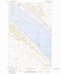
1981 Map of Rat Lake SW
USGS Topo · Published 1981About this map
Lake Sakakawea dominates the landscape in this early 1980s look at the confluence of water and plateau in western North Dakota. The map illustrates the complex shoreline where the Missouri River enters the reservoir, featuring deeply incised drainages and high points like Crow Flies High. The topography reflects a post-dam environment where the rising waters of the mid-20th century transformed the river valley into a vast aquatic expanse, punctuated by landforms like Riverview and the waters of White Earth Bay. On the western shore, the small settlement of Elkhorn sits near the head of the Antelope Creek valley, surrounded by the protected grounds of the State Wildlife Management Area. This survey is particularly useful for understanding the underwater contours of the lake, which were integrated from earlier U.S. Corps of Engineers data to show the original valley floor beneath the current elevation.
Find a feature on this map
11 named features on this map. Tap any name to fly to it.
Don’t see what you’re looking for? This feature index may not catch every label — zoom into the map to look around manually.
Map Details
Editions of this 1981 Rat Lake SW Map
This is the sole edition of this map. No revisions or reprints were ever made.
Other maps of this area

1953 · Williston
USGS Topo · 1:250,000

1953 · Watford City
USGS Topo · 1:250,000

1957 · Williston
USGS Topo · 1:250,000

1957 · Watford City
USGS Topo · 1:250,000

1965 · Charlson
USGS Topo · 1:24,000

1965 · Blue Buttes
USGS Topo · 1:24,000

1965 · Charlson NE
USGS Topo · 1:24,000

1967 · Watford City
USGS Topo · 1:250,000

1967 · Sanish NW
USGS Topo · 1:24,000

1967 · Sanish
USGS Topo · 1:24,000