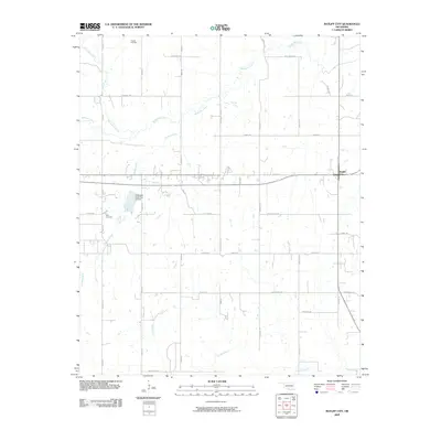
2009 Map of Ratliff City
USGS Topo · Published 2009About this map
Ratliff City and its surrounding rural corridors define this portion of the Oklahoma landscape during the early 21st century. The map reveals a dense network of sectional roads and local routes named for corporate and industrial origins, including Mobil Rd, Sunray Rd, and Continental Rd, reflecting the region's long association with the energy industry. These thoroughfares connect small settlements and burial sites like the Claude Cemetery and Alma Cemetery, providing a clear record of local family and community history. Water management is a visible priority here, evidenced by the Wildhorse Creek Site 14 Dam situated among the drainage basins of Wildhorse Creek and Black Bear Creek. The infrastructure, including routes like Old Hwy 76 and Old Hwy 7, shows how modern transit has layered over established pioneer paths and creek crossings along Panther Creek and Caddo Creek.
Find a feature on this map
38 named features on this map. Tap any name to fly to it.
Don’t see what you’re looking for? This feature index may not catch every label — zoom into the map to look around manually.
Map Details
Editions of this 2009 Ratliff City Map
This is the sole edition of this map. No revisions or reprints were ever made.
Other maps of this area

1898 · Pauls Valley
USGS Topo · 1:125,000

1901 · Addington
USGS Topo · 1:125,000

1901 · Ardmore
USGS Topo · 1:125,000

1902 · Pauls Valley
USGS Topo · 1:125,000

1902 · Rush Springs
USGS Topo · 1:125,000

1918 · Ardmore
USGS Topo · 1:125,000

1957 · Ardmore
USGS Topo · 1:250,000

1963 · Ardmore
USGS Topo · 1:250,000
1969 · Elmore City South
USGS Topo · 1:24,000
1969 · Tatums
USGS Topo · 1:24,000