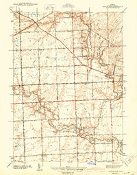
1942 Map of Rattle Run
USGS Topo · Published 1942About this map
The Belle River and Pine River wind through the township of China in this survey based on fieldwork from the late 1930s. The landscape is defined by a dense network of one-room schoolhouses that once served these rural farming communities, including Kennedy Sch, Wright Sch, and Bell Sch. The small settlement of Rattle Run sits in the northwest, while the industrial and residential edges of St Clair and East China occupy the eastern portion of the sheet. Genealogists will find significant value in the documentation of local burial grounds like St Marys Cem and Balfour Cem, as well as the namesake Town Hall located near the river at the junction of Lindsey Road. The intricate drainage system, shown through features like Sheldon Drain and Wolf Drain, illustrates the extensive land management required for agriculture in this part of St. Clair County.
Find a feature on this map
39 named features on this map. Tap any name to fly to it.
Don’t see what you’re looking for? This feature index may not catch every label — zoom into the map to look around manually.
Map Details
Editions of this 1942 Rattle Run Map
2 editions found

Other maps of this area

1912 · Port Huron
USGS Topo · 1:62,500

1914 · Algonac
USGS Topo · 1:62,500

1928 · Hicky
USGS Topo · 1:62,500

1929 · Port Huron
USGS Topo · 1:62,500

1936 · St. Clair
USGS Topo · 1:31,680

1936 · Rattle Run
USGS Topo · 1:31,680

1936 · New Baltimore
USGS Topo · 1:31,680

1939 · New Baltimore
USGS Topo · 1:24,000

1939 · Adair
USGS Topo · 1:24,000

1939 · Port Huron
USGS Topo · 1:24,000
Featured Places
- Saint Clair, MI
- Columbus Township, MI
- East China Charter Township, MI
- Casco Township, MI
- China Charter Township, MI