
1942 Map of Rattle Run
USGS Topo · Published 1942About this map
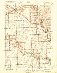
The Belle River meanders through this agricultural section of St. Clair County, anchoring a landscape defined by small rural hubs and a network of named drainage canals. Bell River Mills stands as a focal point in the southern region, while the small settlement of Rattle Run occupies the northwestern corner where Rattle Run Rd meets the water. The map reflects a meticulously organized rural society, with the density of one-room schoolhouses such as Kennedy Sch, Poplar Grove Sch, and Keves Sch indicating the distribution of local families across the townships of St. Clair and China. Near the eastern edge, the terrain transitions toward the developed outskirts of St Clair, where St Marys Cem is situated. This survey captures the region's drainage infrastructure, featuring numerous engineered waterways like Bowman Drain and Hurst Drain that were vital for local farming.
Find a feature on this map
54 named features on this map. Tap any name to fly to it.
Don’t see what you’re looking for? This feature index may not catch every label — zoom into the map to look around manually.
Map Details
Editions of this 1942 Rattle Run Map
2 editions found
Other maps of this area

1912 · Port Huron
USGS Topo · 1:62,500

1914 · Algonac
USGS Topo · 1:62,500

1928 · Hicky
USGS Topo · 1:62,500

1929 · Port Huron
USGS Topo · 1:62,500

1936 · St. Clair
USGS Topo · 1:31,680

1936 · Rattle Run
USGS Topo · 1:31,680

1936 · New Baltimore
USGS Topo · 1:31,680

1939 · New Baltimore
USGS Topo · 1:24,000

1939 · Adair
USGS Topo · 1:24,000

1939 · Port Huron
USGS Topo · 1:24,000
Featured Places
- Saint Clair, MI
- Columbus Township, MI
- East China Charter Township, MI
- Casco Township, MI
- China Charter Township, MI