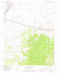
1968 Map of Rattlesnake Hill
USGS Topo · Published 1980About this map
Hualapai Mountains terrain dominates this Arizona landscape, where high-desert canyons meet the expanding infrastructure of the late 1960s. The northern reaches of the map show the transition from the Hualapai Valley into the upland peaks, marked by the prominent Rattlesnake Hill. Key transportation corridors define the northern boundary, including the Atchison Topeka and Santa Fe RR and the development of Interstate 40.
Find a feature on this map
32 named features on this map. Tap any name to fly to it.
Don’t see what you’re looking for? This feature index may not catch every label — zoom into the map to look around manually.
Map Details
Editions of this 1968 Rattlesnake Hill Map
3 editions found
Other maps of this area

1886 · Diamond Creek
USGS Topo · 1:250,000

1886 · Camp Mohave
USGS Topo · 1:250,000

1892 · Diamond Creek
USGS Topo · 1:250,000

1892 · Camp Mohave
USGS Topo · 1:250,000

1939 · Chloride
USGS Topo · 1:48,000

1942 · Camp Mohave
USGS Topo · 1:250,000

1944 · Chloride
USGS Topo · 1:62,500

1947 · Kingman
USGS Topo · 1:250,000

1948 · Kingman
USGS Topo · 1:250,000

1948 · Williams
USGS Topo · 1:250,000