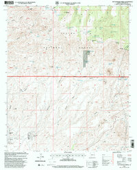
1997 Map of Rattlesnake Spring
USGS Topo · Published 2000About this map
Apache National Forest lands dominate this high-elevation landscape, where a sophisticated network of tanks and springs supported livestock and forest management during the late 20th century. The terrain is defined by dramatic peaks and mesas, from the northern prominence of Sunset Peak and Brushy Mountain to the southern reach of Chalk Peak. Small residential pockets such as Verdee Lee Acres and Loma Linda Estates appear in the southwestern corner, contrasting with the wilderness to the north. Water sources are critical identifiers here, with numerous sites like Rattlesnake Spring, Cold Water Spring, and Gayle Tank scattered across the drainages. These features, along with the Rattlesnake Gap Cabin, reflect the area's history as working rangeland. The map illustrates a rugged topography of canyons and gaps, including Sixshooter Gap and Rattlesnake Gap, which historically dictated travel through the Big Lue Mts.
Find a feature on this map
57 named features on this map. Tap any name to fly to it.
Don’t see what you’re looking for? This feature index may not catch every label — zoom into the map to look around manually.
Map Details
Editions of this 1997 Rattlesnake Spring Map
This is the sole edition of this map. No revisions or reprints were ever made.
Other maps of this area

1902 · Clifton
USGS Topo · 1:62,500

1913 · Morenci
USGS Topo · 1:125,000

1915 · Morenci
USGS Topo · 1:125,000

1954 · Silver City
USGS Topo · 1:250,000

1954 · Clifton
USGS Topo · 1:250,000

1957 · Clifton
USGS Topo · 1:250,000

1958 · Silver City
USGS Topo · 1:250,000

1958 · Clifton
USGS Topo · 1:250,000

1959 · York Valley
USGS Topo · 1:62,500

1960 · Guthrie
USGS Topo · 1:62,500