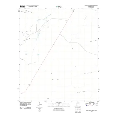
2010 Map of Rattlesnake Springs
USGS Topo · Published 2010About this map
Rattlesnake Spring and the Black River anchor this arid landscape on the New Mexico-Texas border, where water sources have long dictated the placement of remote livestock operations. The topography is defined by the Yeso Hills and a series of deep drainage features such as Rattlesnake Canyon and Slaughter Canyon Draw. Named ranching landmarks like Ballard Ranch, Circle K Ranch, and Old C P Ranch reflect the long history of land use in this corner of Eddy County. Evidence of vital water infrastructure for cattle ranching is visible in the presence of Hoffman Tank, Butcher Well, and the evocative Bottomless Lakes. The map also traces established rural routes including Kingsnake Rd and Ballard Ranch Rd, which connect these isolated homesteads and named features like C P Hill across the Chihuahuan Desert terrain.
Find a feature on this map
26 named features on this map. Tap any name to fly to it.
Don’t see what you’re looking for? This feature index may not catch every label — zoom into the map to look around manually.
Map Details
Editions of this 2010 Rattlesnake Springs Map
This is the sole edition of this map. No revisions or reprints were ever made.
Other maps of this area

1940 · Carlsbad Caverns West
USGS Topo · 1:62,500

1943 · Carlsbad Caverns West
USGS Topo · 1:62,500

1945 · Carlsbad Caverns East
USGS Topo · 1:62,500

1947 · Carlsbad Caverns East
USGS Topo · 1:62,500

1954 · Carlsbad
USGS Topo · 1:250,000

1954 · Van Horn
USGS Topo · 1:250,000

1958 · Van Horn
USGS Topo · 1:250,000

1958 · Carlsbad
USGS Topo · 1:250,000
1973 · Outlaw Spring
USGS Topo · 1:24,000
1973 · South Rector Canyon
USGS Topo · 1:24,000