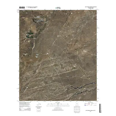
2013 Map of Rattlesnake Springs
USGS Topo · Published 2013About this map
Carlsbad Caverns National Park anchors this portion of Eddy County, preserving a landscape where desert rangeland meet subterranean wonders. The map highlights the vital role of water in this arid environment, centered on the Rattlesnake Springs and the nearby Rattlesnake Springs Picnic Area. Ranching history is deeply etched into the terrain, evidenced by several named homesteads including Ballard Ranch, Circle K Ranch, and the Old C P Ranch. A network of unpaved tracks like Washington Ranch Rd and Ballard Ranch Rd connect these remote outposts, while the National Parks Hwy cuts a straight path across the desert floor toward the caverns. The topography is defined by seasonal drainages like Slaughter Canyon Draw and the limestone formations of the Yeso Hills, illustrating the complex hydrology that feeds Bottomless Lakes and Bottomless Lake Spring.
Find a feature on this map
35 named features on this map. Tap any name to fly to it.
Don’t see what you’re looking for? This feature index may not catch every label — zoom into the map to look around manually.
Map Details
Editions of this 2013 Rattlesnake Springs Map
This is the sole edition of this map. No revisions or reprints were ever made.
Other maps of this area

1940 · Carlsbad Caverns West
USGS Topo · 1:62,500

1943 · Carlsbad Caverns West
USGS Topo · 1:62,500

1945 · Carlsbad Caverns East
USGS Topo · 1:62,500

1947 · Carlsbad Caverns East
USGS Topo · 1:62,500

1954 · Carlsbad
USGS Topo · 1:250,000

1954 · Van Horn
USGS Topo · 1:250,000

1958 · Van Horn
USGS Topo · 1:250,000

1958 · Carlsbad
USGS Topo · 1:250,000
1973 · Outlaw Spring
USGS Topo · 1:24,000
1973 · South Rector Canyon
USGS Topo · 1:24,000