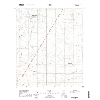
2020 Map of Rattlesnake Springs
USGS Topo · Published 2020About this map
Carlsbad Caverns National Park dominates the northern landscape of this Eddy County quadrangle, marking a transition from the elevated Yeso Hills to the basin floors. The presence of Rattlesnake Springs and the Bottomless Lake Spring provides a rare glimpse into the hydrological complexity of this arid region, where underground water systems emerge at the surface. A network of rural ranch roads, including Mayes Ranch Rd and Dillahunty Rd, crisscrosses the terrain, tracing the paths established by long-standing agricultural and land-management practices. The topography is defined by significant drainage features such as Rattlesnake Canyon and Slaughter Canyon Draw, which channel seasonal runoff through the limestone environment. This 2020 map documents the modern infrastructure and natural landmarks of the area, from the Hoffman Tank to the Kingsnake Rd, supporting both land management and local history research.
Find a feature on this map
27 named features on this map. Tap any name to fly to it.
Don’t see what you’re looking for? This feature index may not catch every label — zoom into the map to look around manually.
Map Details
Editions of this 2020 Rattlesnake Springs Map
This is the sole edition of this map. No revisions or reprints were ever made.
Other maps of this area

1940 · Carlsbad Caverns West
USGS Topo · 1:62,500

1943 · Carlsbad Caverns West
USGS Topo · 1:62,500

1945 · Carlsbad Caverns East
USGS Topo · 1:62,500

1947 · Carlsbad Caverns East
USGS Topo · 1:62,500

1954 · Carlsbad
USGS Topo · 1:250,000

1954 · Van Horn
USGS Topo · 1:250,000

1958 · Van Horn
USGS Topo · 1:250,000

1958 · Carlsbad
USGS Topo · 1:250,000
1973 · Outlaw Spring
USGS Topo · 1:24,000
1973 · South Rector Canyon
USGS Topo · 1:24,000