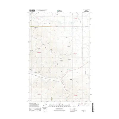
2017 Map of Ravalli
USGS Topo · Published 2017About this map
Ravalli sits at the southern edge of this landscape, where the Jocko River and the Lower Jocko Canal meet the mountain foothills. The terrain transitions from the water-rich meadows of Post Creek and Mission Creek in the north to high-elevation peaks such as Red Sleep Mtn, Telephone Mtn, and Wild Horse Mtn. This intersection of major watercourses and sharp ridges creates a complex network of natural corridors, illustrated by the presence of Getaway Pass and Elk Pass.
Find a feature on this map
63 named features on this map. Tap any name to fly to it.
Don’t see what you’re looking for? This feature index may not catch every label — zoom into the map to look around manually.
Map Details
Editions of this 2017 Ravalli Map
This is the sole edition of this map. No revisions or reprints were ever made.
Other maps of this area

1956 · Wallace
USGS Topo · 1:250,000

1959 · Alberton
USGS Topo · 1:62,500

1959 · Arlee
USGS Topo · 1:62,500

1960 · Wallace
USGS Topo · 1:250,000

1964 · Dixon
USGS Topo · 1:24,000

1964 · Fort Connah
USGS Topo · 1:24,000

1964 · Saint Ignatius
USGS Topo · 1:24,000

1964 · Ravalli
USGS Topo · 1:24,000

1965 · Sloan
USGS Topo · 1:24,000
1965 · Charlo
USGS Topo · 1:24,000