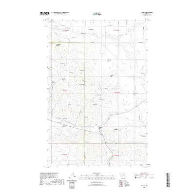
2020 Map of Ravalli
USGS Topo · Published 2020About this map
The Jocko River flows through the southern portion of this landscape, where the settlement of Ravalli sits at the junction of modern transit and older paths. To the north, the terrain rises into significant elevations including Red Sleep Mtn and Telephone Mtn, separated by Getaway Pass. The intricate drainage network of Mission Creek, Post Creek, and Sabine Creek defines the northern flats, where local names like Dublin Gulch and Alexander Basin reflect the early ranching and homesteading geography of Lake and Sanders counties.
Find a feature on this map
61 named features on this map. Tap any name to fly to it.
Don’t see what you’re looking for? This feature index may not catch every label — zoom into the map to look around manually.
Map Details
Editions of this 2020 Ravalli Map
This is the sole edition of this map. No revisions or reprints were ever made.
Other maps of this area

1956 · Wallace
USGS Topo · 1:250,000

1959 · Alberton
USGS Topo · 1:62,500

1959 · Arlee
USGS Topo · 1:62,500

1960 · Wallace
USGS Topo · 1:250,000

1964 · Dixon
USGS Topo · 1:24,000

1964 · Fort Connah
USGS Topo · 1:24,000

1964 · Saint Ignatius
USGS Topo · 1:24,000

1964 · Ravalli
USGS Topo · 1:24,000

1965 · Sloan
USGS Topo · 1:24,000
1965 · Charlo
USGS Topo · 1:24,000