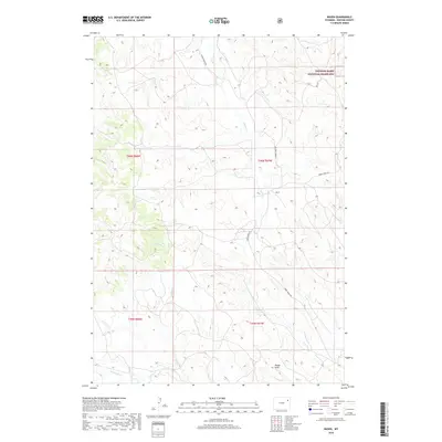
2018 Map of Raven
USGS Topo · Published 2018About this map
Thunder Basin National Grassland dominates this portion of Weston County, where the high plains landscape is defined by a sparse network of seasonal drainages and isolated ranch roads. The settlement of Raven sits at the junction of N Raven Creek Rd and Raven Creek Rd, serving as a central point for the surrounding cattle country. This 2018 survey illustrates the persistent rural character of the region, where water remains the primary driver of topographical names. The southern reaches of the map are drained by Lodgepole Cr and Sage Cr, while the central area features the winding paths of Raven Cr and Lone Tree Cr. Localized landforms like Rough Draw break the undulating terrain, providing a look at the geographic isolation and vast open spaces of northeastern Wyoming.
Find a feature on this map
13 named features on this map. Tap any name to fly to it.
Don’t see what you’re looking for? This feature index may not catch every label — zoom into the map to look around manually.
Map Details
Editions of this 2018 Raven Map
This is the sole edition of this map. No revisions or reprints were ever made.
Other maps of this area

1918 · Moorcroft
USGS Topo · 1:125,000

1954 · Gillette
USGS Topo · 1:250,000

1955 · Newcastle
USGS Topo · 1:250,000

1955 · Gillette
USGS Topo · 1:250,000

1958 · Gillette
USGS Topo · 1:250,000

1958 · Newcastle
USGS Topo · 1:250,000

1962 · Gillette
USGS Topo · 1:250,000
1971 · Whitetail Creek SE
USGS Topo · 1:24,000
1971 · Jim Creek
USGS Topo · 1:24,000
1971 · Buck Creek
USGS Topo · 1:24,000