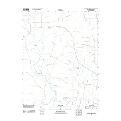
2011 Map of Ravenden Springs SE
USGS Topo · Published 2011About this map
The Eleven Point River carves a winding path through the northern landscape of Randolph County, serving as a primary geographic anchor for this rural Arkansas region. Near the small settlement of Gravesville, the land rises to Cooley Hill, overlooking a network of tributary streams including McIlroy Creek and Ross Creek. This 2011 survey reveals a landscape deeply connected to its past through numerous family and community burial grounds, such as the McIlroy Cemetery, Thomas Cemetery, and Shiloh Cemetery. The distribution of these sites, alongside the presence of the Robinson Broiler Farm and the Blue Basin Lake Dam, reflects a continued reliance on agriculture and water management. Local transportation is defined by a dense network of named tracks and trails, from Blacks Ferry Rd to the winding Greengrove Trl, which connect scattered homesteads and small communities like Lorine and Gravesville across the undulating terrain.
Find a feature on this map
105 named features on this map. Tap any name to fly to it.
Don’t see what you’re looking for? This feature index may not catch every label — zoom into the map to look around manually.
Map Details
Editions of this 2011 Ravenden Springs SE Map
This is the sole edition of this map. No revisions or reprints were ever made.
Other maps of this area

1932 · Walnut Ridge
USGS Topo · 1:62,500

1934 · Powhatan
USGS Topo · 1:62,500

1935 · Powhatan
USGS Topo · 1:62,500

1935 · Reyno
USGS Topo · 1:62,500

1935 · Walnut Ridge
USGS Topo · 1:62,500

1957 · Poplar Bluff
USGS Topo · 1:250,000

1959 · Poplar Bluff
USGS Topo · 1:250,000

1960 · Poplar Bluff
USGS Topo · 1:250,000
1965 · Manson
USGS Topo · 1:24,000

1966 · Ravenden Springs
USGS Topo · 1:24,000