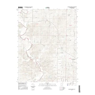
2017 Map of Ravenden Springs SE
USGS Topo · Published 2017About this map
Eleven Point River winds through this section of Randolph County, defining a landscape of complex ridges and narrow creek valleys. The western edge of Pocahontas occupies the southeast corner, while the remainder of the area is characterized by a network of rural trails and roads named for local families and landmarks. The settlement of Lorine sits at a junction of Blacks Ferry Rd and Shiloh Rd, near several important community landmarks including Shiloh Cem and Fivemile Spring. Family history is deeply rooted here, evidenced by numerous burial sites such as Mcllroy Cem, Ross Cem, and Gravesville Cem. The terrain rises toward Cooley Hill, with drainage provided by watercourses like Mcllroy Cr and Vandergriff Cr. The Black Ferry Bridge provides a key crossing point over the river, linking the western hills to the developed outskirts of the county seat.
Find a feature on this map
110 named features on this map. Tap any name to fly to it.
Don’t see what you’re looking for? This feature index may not catch every label — zoom into the map to look around manually.
Map Details
Editions of this 2017 Ravenden Springs SE Map
This is the sole edition of this map. No revisions or reprints were ever made.
Other maps of this area

1932 · Walnut Ridge
USGS Topo · 1:62,500

1934 · Powhatan
USGS Topo · 1:62,500

1935 · Powhatan
USGS Topo · 1:62,500

1935 · Reyno
USGS Topo · 1:62,500

1935 · Walnut Ridge
USGS Topo · 1:62,500

1957 · Poplar Bluff
USGS Topo · 1:250,000

1959 · Poplar Bluff
USGS Topo · 1:250,000

1960 · Poplar Bluff
USGS Topo · 1:250,000
1965 · Manson
USGS Topo · 1:24,000

1966 · Ravenden Springs
USGS Topo · 1:24,000