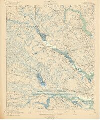
1920 Map of Ravenels
USGS Topo · Published 1920About this map
The Ashley River and Stono River define the Lowcountry landscape of this 1918 survey, where colonial history meets early 20th-century industry. The ruins at Old Dorchester stand as a silent witness to early settlement patterns, while the nearby Middleton Garden and Ashley Hall reflect the region’s established estate culture. The map captures a transition in land use, showing the Tyler Tea Farm alongside industrial developments like the Bula Mines and the extensive Charleston Waterworks at the Goose Creek Reservoir.
Find a feature on this map
89 named features on this map. Tap any name to fly to it.
Don’t see what you’re looking for? This feature index may not catch every label — zoom into the map to look around manually.
Map Details
Editions of this 1920 Ravenels Map
3 editions found

Other maps of this area

1918 · Cottageville
USGS Topo · 1:62,500

1919 · Ladson
USGS Topo · 1:21,120

1919 · Johns Island
USGS Topo · 1:21,120

1919 · Summerville
USGS Topo · 1:48,000

1919 · Edisto Island
USGS Topo · 1:62,500

1919 · Ridgeville
USGS Topo · 1:48,000

1919 · Wadmelaw Island
USGS Topo · 1:62,500

1919 · Cordesville
USGS Topo · 1:48,000

1919 · Melgrove
USGS Topo · 1:21,120

1919 · Charleston
USGS Topo · 1:21,120