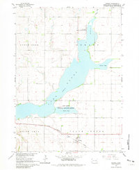
1964 Map of Ravinia
USGS Topo · Published 1981About this map
Lake Andes dominates the landscape of this mid-century Dakota survey, serving as a focal point for both local recreation and conservation. The Lake Andes National Wildlife Refuge encompasses significant portions of the shoreline, including Owens Bay and the northern reaches of the lake. To the south, the settlement of Ravinia sits along the Chicago Milwaukee St Paul and Pacific railroad line, which cuts through the townships of White Swan and Plain Center. The map reveals a rural economy dependent on these rail connections and the managed waters of the region, evidenced by the presence of the Flowing Well and local landmarks like the West Sch and the small siding at Dezera. The intricate network of section lines and field boundaries highlights the organized agricultural expansion typical of Charles Mix County during this era.
Find a feature on this map
15 named features on this map. Tap any name to fly to it.
Don’t see what you’re looking for? This feature index may not catch every label — zoom into the map to look around manually.
Map Details
Editions of this 1964 Ravinia Map
2 editions found
Other maps of this area

1955 · Mitchell
USGS Topo · 1:250,000

1959 · Mitchell
USGS Topo · 1:250,000

1964 · Wagner NE
USGS Topo · 1:24,000

1964 · Ravinia
USGS Topo · 1:24,000

1964 · Fort Randall Dam
USGS Topo · 1:24,000

1964 · Lake Andes
USGS Topo · 1:24,000

1964 · Wagner
USGS Topo · 1:24,000

1964 · Wagner SW
USGS Topo · 1:24,000
1977 · Wagner
USGS Topo · 1:24,000
1977 · Wagner SW
USGS Topo · 1:24,000
Featured Places
- Ravinia, SD
- Howard Township, SD
- Lake View Hutterite Colony, SD
- Goose Lake Township, SD
- White Swan Township, SD