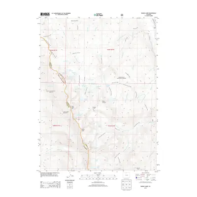
2013 Map of Rawah Lakes
USGS Topo · Published 2013About this map
Rawah Ranch and the headwaters of the Laramie River anchor the northeastern corner of this high-altitude landscape along the border of Larimer and Jackson counties. The terrain is defined by the high crests of the Medicine Bow Mountains, including North Rawah Peak and South Rawah Peak, which separate the watersheds of McIntyre Creek and the West Branch Laramie River. A complex network of trails, such as the Rawah Trail and Sandbar Lakes Trail, provides access to dozens of alpine water bodies like Big Rainbow Lake and Island Lake. Significant human management of the water is evident through the Rawah and Lower Supply Ditch and the Skyline Ditch, which divert flows across the rugged topography. The presence of the Big McIntyre Burn in the north serves as a reminder of the forest's shifting ecology within the Roosevelt National Forest.
Find a feature on this map
73 named features on this map. Tap any name to fly to it.
Don’t see what you’re looking for? This feature index may not catch every label — zoom into the map to look around manually.
Map Details
Editions of this 2013 Rawah Lakes Map
This is the sole edition of this map. No revisions or reprints were ever made.
Other maps of this area

1916 · Home
USGS Topo · 1:125,000

1920 · Home
USGS Topo · 1:125,000

1954 · Greeley
USGS Topo · 1:250,000

1954 · Craig
USGS Topo · 1:250,000

1955 · Gould
USGS Topo · 1:24,000

1955 · Shipman Mountain
USGS Topo · 1:24,000

1955 · Kings Canyon
USGS Topo · 1:62,500

1956 · Johnny Moore Mountain
USGS Topo · 1:24,000
1956 · Gould
USGS Topo · 1:62,500

1957 · Craig
USGS Topo · 1:250,000