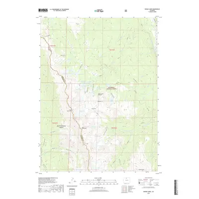
2019 Map of Rawah Lakes
USGS Topo · Published 2019About this map
High alpine hydrology and the spine of the Medicine Bow Mountains define this section of the Roosevelt National Forest. The landscape is dominated by the Rawah Lakes chain, including numbered basins from Rawah Lake Number 1 through Rawah Lake Number 4. Water management is evident along the eastern edge, where the Laramie River is tapped by the Rawah and Lower Supply Ditch, a system supporting downstream agriculture from high-elevation sources. The terrain is marked by significant summits like North Rawah Peak and South Rawah Peak, separated by Grassy Pass. This area, bordering the Routt National Forest, contains a dense network of high-altitude water bodies such as McIntyre Lake, Sugarbowl Lake, and the aptly named Iceberg Lake. Recreational and surveyor access is noted via the Camp Lake Loop and the Clear Lake Trail, which navigate the steep transition from timberline to rocky peaks.
Find a feature on this map
63 named features on this map. Tap any name to fly to it.
Don’t see what you’re looking for? This feature index may not catch every label — zoom into the map to look around manually.
Map Details
Editions of this 2019 Rawah Lakes Map
This is the sole edition of this map. No revisions or reprints were ever made.
Other maps of this area

1916 · Home
USGS Topo · 1:125,000

1920 · Home
USGS Topo · 1:125,000

1954 · Greeley
USGS Topo · 1:250,000

1954 · Craig
USGS Topo · 1:250,000

1955 · Gould
USGS Topo · 1:24,000

1955 · Shipman Mountain
USGS Topo · 1:24,000

1955 · Kings Canyon
USGS Topo · 1:62,500

1956 · Johnny Moore Mountain
USGS Topo · 1:24,000
1956 · Gould
USGS Topo · 1:62,500

1957 · Craig
USGS Topo · 1:250,000