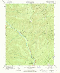
1967 Map of Rawley Springs
USGS Topo · Published 1969About this map
Rawley Springs serves as the focal point for this mountain landscape in the late 1960s, situated at the confluence of several highland drainages within the George Washington National Forest. The hydrological network is the dominant feature of the terrain, with Dry River and its various tributaries like Skidmore Fork and Gum Run carving deep valleys between ridges. Human activity is centered around the recreation and water management infrastructure, notably the Harrisonburg Reservoir and the Riven Rock Picnic Area. Genealogists and local historians may find interest in the peripheral markers of settlement, such as the Oak Grove Cem and the naming of remote points like Clines Hacking. The map illustrates a period of established forest management and watershed protection, characterized by a complex system of fire trails and ridge-top paths including the Dull Hunt Trail and Sand Spring Trail that navigate the slopes of Bald Knob and Second Mountain.
Find a feature on this map
56 named features on this map. Tap any name to fly to it.
Don’t see what you’re looking for? This feature index may not catch every label — zoom into the map to look around manually.
Map Details
Editions of this 1967 Rawley Springs Map
4 editions found
Other maps of this area

1892 · Franklin
USGS Topo · 1:125,000

1892 · Woodstock
USGS Topo · 1:125,000

1892 · Harrisonburg
USGS Topo · 1:125,000

1894 · Staunton
USGS Topo · 1:125,000

1896 · Franklin
USGS Topo · 1:125,000

1922 · Fort Seybert
USGS Topo · 1:48,000

1924 · Fort Seybert
USGS Topo · 1:62,500

1941 · Harrisonburg
USGS Topo · 1:62,500

1943 · Harrisonburg
USGS Topo · 1:62,500

1944 · Parnassus
USGS Topo · 1:62,500