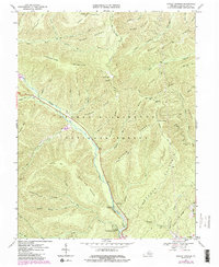
1967 Map of Rawley Springs
USGS Topo · Published 1984About this map
Rawley Springs serves as the primary focal point in this portion of the George Washington National Forest, where the complex drainage of the Dry River and Skidmore Fork shapes the landscape. The terrain is defined by prominent ridges including Feedstone Mountain, Dictum Ridge, and Second Mountain, illustrating the deeply dissected topography of the Alleghenies. Local history is anchored by sites like the Oak Grove Cem and the Riven Rock Picnic Area, while numerous named runs and springs, such as Miller Spring and Maple Spring Run, indicate the vital water sources that supported early residents and timber activities.
Find a feature on this map
56 named features on this map. Tap any name to fly to it.
Don’t see what you’re looking for? This feature index may not catch every label — zoom into the map to look around manually.
Map Details
Editions of this 1967 Rawley Springs Map
4 editions found
Other maps of this area

1892 · Franklin
USGS Topo · 1:125,000

1892 · Woodstock
USGS Topo · 1:125,000

1892 · Harrisonburg
USGS Topo · 1:125,000

1894 · Staunton
USGS Topo · 1:125,000

1896 · Franklin
USGS Topo · 1:125,000

1922 · Fort Seybert
USGS Topo · 1:48,000

1924 · Fort Seybert
USGS Topo · 1:62,500

1941 · Harrisonburg
USGS Topo · 1:62,500

1943 · Harrisonburg
USGS Topo · 1:62,500

1944 · Parnassus
USGS Topo · 1:62,500