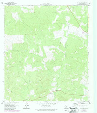
1971 Map of Ray Lake SW
USGS Topo · Published 1987About this map
Davis Cave sits within the drainage of the West Nueces River, characterizing this Edwards County landscape in the early 1970s. The map illustrates a primarily ranching and resource-based economy, defined by scattered water Tanks and multiple Gravel Pits used for local infrastructure and road maintenance. The presence of a private Landing Strip suggests the logistical importance of aviation in this isolated portion of the Texas Hill Country, where rugged relief separates the river valley from Geronimo Creek. The detailed contour lines reveal the winding canyon paths and limestone geography typical of the Edwards Plateau, capturing a moment before late-century land-use changes altered the area's rural character.
Find a feature on this map
6 named features on this map. Tap any name to fly to it.
Don’t see what you’re looking for? This feature index may not catch every label — zoom into the map to look around manually.
Map Details
Editions of this 1971 Ray Lake SW Map
2 editions found
Other maps of this area

1893 · Rock Springs
USGS Topo · 1:125,000

1893 · Nueces
USGS Topo · 1:125,000

1896 · Nueces
USGS Topo · 1:125,000

1943 · Carta Valley
USGS Topo · 1:62,500

1944 · Indian Creek
USGS Topo · 1:62,500

1954 · Sonora
USGS Topo · 1:250,000

1958 · Sonora
USGS Topo · 1:250,000

1958 · Del Rio
USGS Topo · 1:250,000

1964 · Del Rio
USGS Topo · 1:250,000

1970 · Ray Lake NW
USGS Topo · 1:24,000