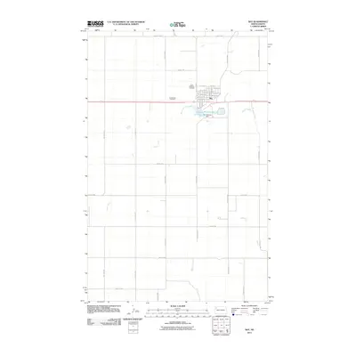
2011 Map of Ray
USGS Topo · Published 2011About this map
The town of Ray serves as the central hub of this Williams County landscape, organized by a strict section-line grid typical of the Great Plains. The settlement is anchored by a detailed street plan including Main St, Church St, and Lake St, reflecting its role as a regional service point. Just south of the town center, McLeod Lake and the Ray Railroad Dam highlight the critical role of water management and rail infrastructure in supporting local industry and life. The presence of both Saint Michaels Cemetery and Sunset Rest Cemetery on the periphery of the town provides valuable points of interest for genealogists tracing early families. Beyond the town limits, the landscape is defined by the winding course of Beaver Creek and a network of rural roads like County Hwy-17, illustrating the vast agricultural stretches that surround this North Dakota community.
Find a feature on this map
34 named features on this map. Tap any name to fly to it.
Don’t see what you’re looking for? This feature index may not catch every label — zoom into the map to look around manually.
Map Details
Editions of this 2011 Ray Map
This is the sole edition of this map. No revisions or reprints were ever made.
Other maps of this area

1911 · Ray
USGS Topo · 1:125,000

1953 · Williston
USGS Topo · 1:250,000

1957 · Williston
USGS Topo · 1:250,000

1969 · Cussicks Spring
USGS Topo · 1:24,000

1969 · Red Mike Hill
USGS Topo · 1:24,000

1978 · Ray
USGS Topo · 1:24,000

1978 · Ray SE
USGS Topo · 1:24,000

1978 · Temple
USGS Topo · 1:24,000

1978 · Ray NW
USGS Topo · 1:24,000
1978 · Epping NE
USGS Topo · 1:24,000