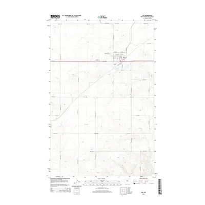
2014 Map of Ray
USGS Topo · Published 2014About this map
Ray serves as the focal point of this Williams County landscape, situated along the primary east-west corridor of Us-2. The town’s grid is clearly defined by local streets such as Lake St and Winther St, while the surrounding prairie is marked by a systematic network of section roads like 115th Ave NW. This survey captures the transition from the town’s residential core to the nearby recreational and memorial sites, including McLeod Lake and Golf Course Rd. Genealogists will find the locations of Saint Michaels Cem and Sunset Rest Cem particularly useful, as they lie just west of the main settlement. The natural hydrology is defined by the winding course of Beaver Cr, which meanders through the western half of the quadrangle, providing a sharp contrast to the rigid, man-made grid of the agricultural and transportation infrastructure.
Find a feature on this map
36 named features on this map. Tap any name to fly to it.
Don’t see what you’re looking for? This feature index may not catch every label — zoom into the map to look around manually.
Map Details
Editions of this 2014 Ray Map
This is the sole edition of this map. No revisions or reprints were ever made.
Other maps of this area

1911 · Ray
USGS Topo · 1:125,000

1953 · Williston
USGS Topo · 1:250,000

1957 · Williston
USGS Topo · 1:250,000

1969 · Cussicks Spring
USGS Topo · 1:24,000

1969 · Red Mike Hill
USGS Topo · 1:24,000

1978 · Ray
USGS Topo · 1:24,000

1978 · Ray SE
USGS Topo · 1:24,000

1978 · Temple
USGS Topo · 1:24,000

1978 · Ray NW
USGS Topo · 1:24,000
1978 · Epping NE
USGS Topo · 1:24,000