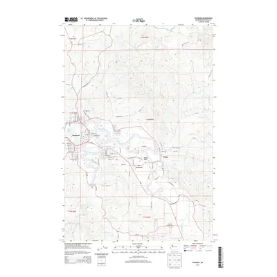
2014 Map of Raymond
USGS Topo · Published 2014About this map
Raymond serves as the primary hub where the Willapa River meets its major tidal tributaries, creating a landscape defined by sloughs and wetlands. This early 21st-century survey documents the spatial relationship between the town center and outlying communities like East Raymond, Willapa, and Willapa Valley. The terrain rises sharply from the riverbanks toward timbered ridges, with the valley floor supporting recreation at the Willapa Harbor Golf Course and vital local water resources like the Raymond Heights Reservoir.
Find a feature on this map
95 named features on this map. Tap any name to fly to it.
Don’t see what you’re looking for? This feature index may not catch every label — zoom into the map to look around manually.
Map Details
Editions of this 2014 Raymond Map
This is the sole edition of this map. No revisions or reprints were ever made.
Other maps of this area

1938 · South Bend
USGS Topo · 1:62,500

1940 · Montesano
USGS Topo · 1:62,500

1940 · South Bend
USGS Topo · 1:62,500

1953 · Hoquiam
USGS Topo · 1:250,000

1955 · Montesano
USGS Topo · 1:62,500

1955 · Raymond
USGS Topo · 1:62,500
1955 · North Nemah
USGS Topo · 1:24,000

1955 · Aberdeen SE
USGS Topo · 1:24,000

1957 · Hoquiam
USGS Topo · 1:250,000
1957 · South Bend
USGS Topo · 1:24,000