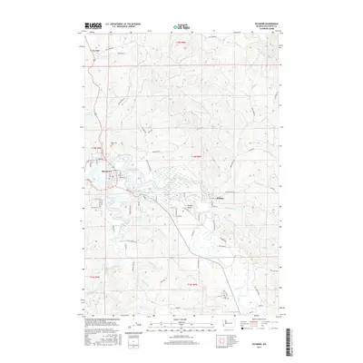
2017 Map of Raymond
USGS Topo · Published 2017About this map
The Willapa River and its complex tidal reaches define the landscape around the town of Raymond and the community of Willapa. This 2017 study illustrates the dense network of drainage and sloughs that feed into the main channel, including Ellis Slough and South Fork Willapa River. The timber and agricultural legacy of Pacific County is visible in the network of logging roads like G Line Rd and A Line Rd that snake through the uplands, while the valley floor is occupied by the residential areas of Willapa Valley and Raymond Heights Reservoir. For genealogists, the map identifies significant burial sites including Washington Cem near the town center and Fern Hill Cem to the southeast. These landmarks, along with many family-named features like Donaldson Cr and Lilly Wheaton Rd, offer a detailed view of the modern settlement pattern in this coastal river valley.
Find a feature on this map
81 named features on this map. Tap any name to fly to it.
Don’t see what you’re looking for? This feature index may not catch every label — zoom into the map to look around manually.
Map Details
Editions of this 2017 Raymond Map
This is the sole edition of this map. No revisions or reprints were ever made.
Other maps of this area

1938 · South Bend
USGS Topo · 1:62,500

1940 · Montesano
USGS Topo · 1:62,500

1940 · South Bend
USGS Topo · 1:62,500

1953 · Hoquiam
USGS Topo · 1:250,000

1955 · Montesano
USGS Topo · 1:62,500

1955 · Raymond
USGS Topo · 1:62,500
1955 · North Nemah
USGS Topo · 1:24,000

1955 · Aberdeen SE
USGS Topo · 1:24,000

1957 · Hoquiam
USGS Topo · 1:250,000
1957 · South Bend
USGS Topo · 1:24,000