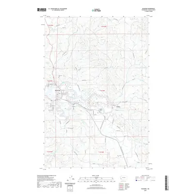
2020 Map of Raymond
USGS Topo · Published 2020About this map
Raymond serves as the focal point of this coastal Washington landscape, where the confluence of the Willapa River and the South Fork Willapa River creates a network of tidal channels and sloughs. The geography is defined by its proximity to the water, featuring Ellis Slough and Case Pond alongside the larger river systems. To the east, the settlement of Willapa and the Willapa Valley occupy the lowlands before the terrain rises into timbered ridges. Genealogists will find the Washington Cem near the town center and Fern Hill Cem situated further south. Evidence of the region’s timber and rail history is preserved in the route of the Willapa Hills State Park Trail, which follows the river corridor eastward. Infrastructure for the local population is marked by the Butte Cr Reservoir and Raymond Heights Reservoir, reflecting the managed water resources of Pacific County.
Find a feature on this map
82 named features on this map. Tap any name to fly to it.
Don’t see what you’re looking for? This feature index may not catch every label — zoom into the map to look around manually.
Map Details
Editions of this 2020 Raymond Map
This is the sole edition of this map. No revisions or reprints were ever made.
Other maps of this area

1938 · South Bend
USGS Topo · 1:62,500

1940 · Montesano
USGS Topo · 1:62,500

1940 · South Bend
USGS Topo · 1:62,500

1953 · Hoquiam
USGS Topo · 1:250,000

1955 · Montesano
USGS Topo · 1:62,500

1955 · Raymond
USGS Topo · 1:62,500
1955 · North Nemah
USGS Topo · 1:24,000

1955 · Aberdeen SE
USGS Topo · 1:24,000

1957 · Hoquiam
USGS Topo · 1:250,000
1957 · South Bend
USGS Topo · 1:24,000