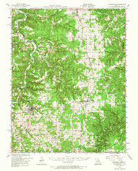
1951 Map of Raymondville
USGS Topo · Published 1967About this map
The Big Piney River and its tributary Boone Creek carve a winding course through this mid-century landscape in the heart of Texas County. The map reveals a rural economy centered on small, dispersed communities like Raymondville, Licking, and Houston, where the timber industry is represented by the Steam Mill located near Glass Cem. The rugged terrain of the Mark Twain National Forest is dotted with numerous one-room schoolhouses and country churches, such as the Prescott School and Cantrell Church, which served as the social anchors for family farms. Evidence of the early road network is found at natural crossings like Sandy Shoal Ford and Mineral Springs Ford, while the presence of the Warlock School (abandoned) suggests the beginning of the rural school consolidation era that would eventually alter the county’s social geography.
Find a feature on this map
79 named features on this map. Tap any name to fly to it.
Don’t see what you’re looking for? This feature index may not catch every label — zoom into the map to look around manually.
Map Details
Editions of this 1951 Raymondville Map
3 editions found

Other maps of this area

1932 · Cedar Grove
USGS Topo · 1:48,000

1937 · Edgar Springs
USGS Topo · 1:48,000

1941 · Big Piney
USGS Topo · 1:62,500

1941 · Salem
USGS Topo · 1:62,500

1941 · Bado
USGS Topo · 1:62,500

1943 · Big Piney
USGS Topo · 1:62,500

1943 · Bado
USGS Topo · 1:62,500

1945 · Salem
USGS Topo · 1:62,500

1945 · Edgar Springs
USGS Topo · 1:62,500

1945 · Clear Springs
USGS Topo · 1:62,500