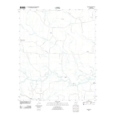
2011 Map of Reader
USGS Topo · Published 2011About this map
Whelen Springs and the small settlements of Sayre and Reader anchor this topographic survey of the Arkansas timberlands. The landscape is defined by the winding course of the Little Missouri River, which creates distinctive geographical features like Horseshoe Bend and the crossing at Riffe Ford. Historically significant sites for local genealogy include the Bethlehem Cemetery located near Beech Creek and the Jenkins Cemetery to the east. The terrain rises to notable elevations at Bull Mountain and Gores Peak in the north, while the southern reaches are marked by low-lying wetlands such as Horn Lake and Salt Lake. A network of rural routes, including Kansas Rd and Quachita Road 74, connects these isolated communities and family-named landmarks like Polk Stinnett Hill.
Find a feature on this map
58 named features on this map. Tap any name to fly to it.
Don’t see what you’re looking for? This feature index may not catch every label — zoom into the map to look around manually.
Map Details
Editions of this 2011 Reader Map
This is the sole edition of this map. No revisions or reprints were ever made.
Other maps of this area

1901 · Gurdon
USGS Topo · 1:125,000

1903 · Camden
USGS Topo · 1:125,000

1953 · El Dorado
USGS Topo · 1:250,000

1957 · El Dorado
USGS Topo · 1:250,000

1958 · El Dorado
USGS Topo · 1:250,000

1960 · El Dorado
USGS Topo · 1:250,000

1970 · Whelen Springs
USGS Topo · 1:24,000

1970 · Reader
USGS Topo · 1:24,000
1970 · Gurdon
USGS Topo · 1:24,000
1970 · Curtis
USGS Topo · 1:24,000