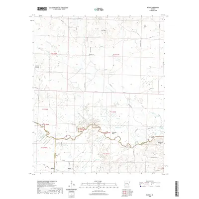
2020 Map of Reader
USGS Topo · Published 2020About this map
The Little Missouri River meanders across this landscape, forming the natural boundary between Clark, Nevada, and Ouachita counties. The river valley is defined by intricate wetlands and oxbow features like Horseshoe Bend, Minnie Slough, and Bolin Slough. On the northern banks, the terrain rises toward Bull Mtn and Gores Peak, while the southern reaches contain the settlements of Reader and Sayre. This area is characterized by its network of rural roads, including Kansas RD and Co RD 40, which connect isolated homesteads and local landmarks. Genealogists will find several notable burial sites documented, such as Bethlehem Cem, Jenkins Cem, and the Lewis Randolph Grave. Further east, the landscape transitions into the bottomlands near Salt Lake and Barton Lake, illustrating the complex hydrology of the basin south of Whelen Springs.
Find a feature on this map
70 named features on this map. Tap any name to fly to it.
Don’t see what you’re looking for? This feature index may not catch every label — zoom into the map to look around manually.
Map Details
Editions of this 2020 Reader Map
This is the sole edition of this map. No revisions or reprints were ever made.
Other maps of this area

1901 · Gurdon
USGS Topo · 1:125,000

1903 · Camden
USGS Topo · 1:125,000

1953 · El Dorado
USGS Topo · 1:250,000

1957 · El Dorado
USGS Topo · 1:250,000

1958 · El Dorado
USGS Topo · 1:250,000

1960 · El Dorado
USGS Topo · 1:250,000

1970 · Whelen Springs
USGS Topo · 1:24,000

1970 · Reader
USGS Topo · 1:24,000
1970 · Gurdon
USGS Topo · 1:24,000
1970 · Curtis
USGS Topo · 1:24,000