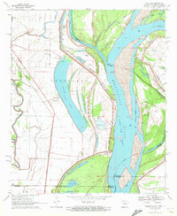
1970 Map of Readland
USGS Topo · Published 1972About this map
Grand Lake dominates this 1970 landscape, its crescent shape defining the alluvial plain at the intersection of Arkansas, Louisiana, and Mississippi. The small settlements of Readland and Arkla sit west of the lake, served by the Missouri Pacific railroad line. Along the river, a complex system of hydraulic engineering is evident, from the massive Levee system shielding the lowlands to the Grand Lake Cutoff and the northern reach of Kentucky Bend.
Find a feature on this map
27 named features on this map. Tap any name to fly to it.
Don’t see what you’re looking for? This feature index may not catch every label — zoom into the map to look around manually.
Map Details
Editions of this 1970 Readland Map
This is the sole edition of this map. No revisions or reprints were ever made.
Other maps of this area

1909 · Wilsons Point
USGS Topo · 1:24,000

1909 · Millikin
USGS Topo · 1:24,000

1909 · Ashton Bridge
USGS Topo · 1:24,000

1912 · Ashton Bridge
USGS Topo · 1:31,680

1913 · Wilson Point
USGS Topo · 1:31,680

1935 · Oak Grove
USGS Topo · 1:62,500

1936 · Eudora
USGS Topo · 1:62,500

1939 · Readland
USGS Topo · 1:62,500

1939 · Mayersville
USGS Topo · 1:62,500

1953 · Greenwood
USGS Topo · 1:250,000