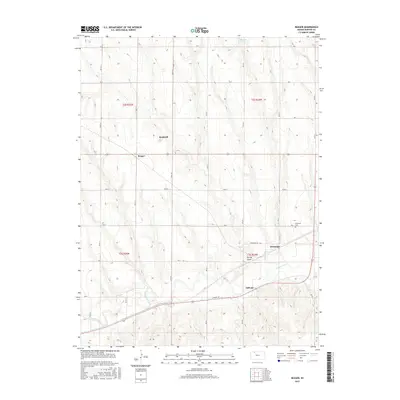
2015 Map of Reager
USGS Topo · Published 2015About this map
Oronoque and Dellvale anchor the southern reaches of this Norton County landscape, where the meandering course of Prairie Dog Cr cuts through the plains. The map illustrates a strictly ordered section-line road grid, including Airport Rd and Oronoque Rd, which connect the small clusters of Reager and Rockwell to the larger surrounding township. These rural settlements and the Oronoque Cem provide essential anchor points for genealogists and local historians tracing family landholdings in northern Kansas. Land use is predominantly defined by the Public Land Survey System, with township and range boundaries such as t2s r25w and t2s r24w clearly demarcated. Water sources like Spring Draw and Browns Pond offer insight into the natural drainage patterns of this high-plains region, reflecting the agricultural character of the era.
Find a feature on this map
21 named features on this map. Tap any name to fly to it.
Don’t see what you’re looking for? This feature index may not catch every label — zoom into the map to look around manually.
Map Details
Editions of this 2015 Reager Map
This is the sole edition of this map. No revisions or reprints were ever made.
Other maps of this area

1893 · Norton
USGS Topo · 1:125,000

1951 · Norton
USGS Topo · 1:62,500

1951 · Norcatur
USGS Topo · 1:62,500

1954 · Goodland
USGS Topo · 1:250,000

1955 · Beloit
USGS Topo · 1:250,000

1956 · Goodland
USGS Topo · 1:250,000

1957 · Goodland
USGS Topo · 1:250,000

1959 · Beloit
USGS Topo · 1:250,000
1965 · Norton NW
USGS Topo · 1:24,000
1965 · Lyle
USGS Topo · 1:24,000