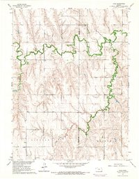
1965 Map of Lyle
USGS Topo · Published 1966About this map
Sappa Creek winds through the northern half of this mid-1960s survey, defining the agricultural landscape at the border of Decatur and Norton counties. The settlement of Lyle serves as a central point in an area largely characterized by section lines and family-named landmarks. Genealogists will find significant value in the distribution of rural burial grounds, including Railsback Cem, Walton Cem, Wray Cem, and Shirley Cem, which reflect the early homesteading patterns of Grant, Crystal, and Lincoln townships. The local economy is represented by more modern developments such as an Oil Well, a Gravel Pit, and a dedicated Landing Strip, illustrating the diversification of the High Plains prairie beyond traditional farming into resource extraction and private aviation.
Find a feature on this map
17 named features on this map. Tap any name to fly to it.
Don’t see what you’re looking for? This feature index may not catch every label — zoom into the map to look around manually.
Map Details
Editions of this 1965 Lyle Map
This is the sole edition of this map. No revisions or reprints were ever made.
Other maps of this area

1951 · Norcatur
USGS Topo · 1:62,500

1951 · Kanona
USGS Topo · 1:62,500

1954 · McCook
USGS Topo · 1:250,000

1954 · Goodland
USGS Topo · 1:250,000

1956 · Goodland
USGS Topo · 1:250,000

1957 · McCook
USGS Topo · 1:250,000

1957 · Goodland
USGS Topo · 1:250,000

1957 · Shippee
USGS Topo · 1:24,000
1957 · Wilsonville
USGS Topo · 1:24,000

1957 · Lebanon
USGS Topo · 1:24,000