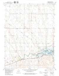
1978 Map of Reager
USGS Topo · Published 1979About this map
Prairie Dog Creek defines the lower third of this western Kansas landscape, feeding into the Norton Reservoir as it appeared in the late 1970s. The water is flanked by the Leota Game Management Area, while the surrounding terrain is marked by a network of drainage systems like Dog Creek and Spring Draw. This survey captures the transportation infrastructure of Norton County during a period of transition, showing the crossing of the Burlington Northern and the Chicago Rock Island and Pacific railroads.
Find a feature on this map
20 named features on this map. Tap any name to fly to it.
Don’t see what you’re looking for? This feature index may not catch every label — zoom into the map to look around manually.
Map Details
Editions of this 1978 Reager Map
This is the sole edition of this map. No revisions or reprints were ever made.
Other maps of this area

1893 · Norton
USGS Topo · 1:125,000

1951 · Norton
USGS Topo · 1:62,500

1951 · Norcatur
USGS Topo · 1:62,500

1954 · Goodland
USGS Topo · 1:250,000

1955 · Beloit
USGS Topo · 1:250,000

1956 · Goodland
USGS Topo · 1:250,000

1957 · Goodland
USGS Topo · 1:250,000

1959 · Beloit
USGS Topo · 1:250,000
1965 · Norton NW
USGS Topo · 1:24,000
1965 · Lyle
USGS Topo · 1:24,000