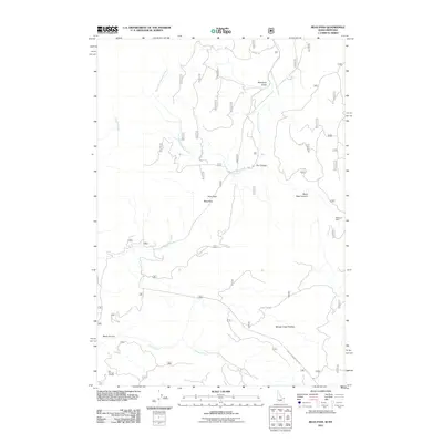
2011 Map of Reas Pass
USGS Topo · Published 2011About this map
The South Fork Madison River winds through this high-country landscape on the Montana-Idaho border, a region defined by its complex network of watercourses and forest service access. Near the northeastern corner, Whitmans Cabin sits as a lonely landmark among the timbered slopes, while the high vantage of Big Springs Lookout provides a key point of reference to the southwest. The terrain is deeply incised by drainages such as Mosquito Gulch, Black Bear Canyon, and Dry Canyon, all of which feed the river system.
Find a feature on this map
18 named features on this map. Tap any name to fly to it.
Don’t see what you’re looking for? This feature index may not catch every label — zoom into the map to look around manually.
Map Details
Editions of this 2011 Reas Pass Map
This is the sole edition of this map. No revisions or reprints were ever made.
Other maps of this area

1955 · Ashton
USGS Topo · 1:250,000

1957 · Buffalo Lake
USGS Topo · 1:62,500

1958 · Ashton
USGS Topo · 1:250,000

1958 · West Yellowstone
USGS Topo · 1:62,500

1960 · Ashton
USGS Topo · 1:250,000

1964 · Island Park
USGS Topo · 1:24,000

1964 · Targhee Pass
USGS Topo · 1:24,000

1964 · Big Springs
USGS Topo · 1:24,000

1964 · Henrys Lake
USGS Topo · 1:62,500
1986 · Jack Straw Basin
USGS Topo · 1:24,000