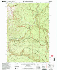
2000 Map of Reas Pass
USGS Topo · Published 2005About this map
The Continental Divide defines the high boundary of this landscape, marking the border between Fremont and Gallatin counties and the state line between Montana and Idaho. Located within the Targhee National Forest, the area is characterized by a network of seasonal routes and high-elevation waterways. The Continental Divide National Scenic Trail winds along the ridge, while specialized paths like the Two Top Snowmobile Trail emphasize the region's recreational use. Historical remnants are found at the Big Springs Lookout (Site) and a Comm Site, suggesting the area's importance for observation and communication in the high backcountry. Significant drainage systems include the South Fork Madison River and various canyons such as Dry Canyon and Black Canyon, which collect runoff from the surrounding peaks and the expansive Plateau to the south.
Find a feature on this map
23 named features on this map. Tap any name to fly to it.
Don’t see what you’re looking for? This feature index may not catch every label — zoom into the map to look around manually.
Map Details
Editions of this 2000 Reas Pass Map
This is the sole edition of this map. No revisions or reprints were ever made.
Other maps of this area

1955 · Ashton
USGS Topo · 1:250,000

1957 · Buffalo Lake
USGS Topo · 1:62,500

1958 · Ashton
USGS Topo · 1:250,000

1958 · West Yellowstone
USGS Topo · 1:62,500

1960 · Ashton
USGS Topo · 1:250,000

1964 · Island Park
USGS Topo · 1:24,000

1964 · Targhee Pass
USGS Topo · 1:24,000

1964 · Big Springs
USGS Topo · 1:24,000

1964 · Henrys Lake
USGS Topo · 1:62,500
1986 · Jack Straw Basin
USGS Topo · 1:24,000