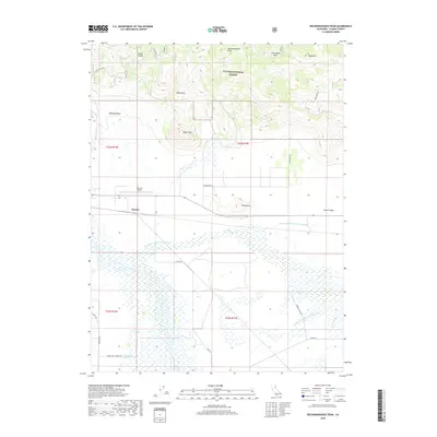
2018 Map of Reconnaissance Peak
USGS Topo · Published 2018About this map
Sierra Valley dominates the lower half of this landscape, where a complex network of agricultural and natural waterways includes the N Channel Little Last Chance Cr, E Channel Little Last Chance Cr, and Dyson Slough. This level basin contrasts sharply with the northern mountainous terrain of the Plumas National Forest, marked by prominent high points such as Reconnaissance Peak, Sugar Loaf, and Table Rock. The small settlement of Hawley and the nearby Nervino Airport serve as central landmarks at the transition between the valley floor and the rising uplands. To the south, the presence of Marble Hot Springs indicates the geothermal activity of the region, while named features like Dotta Saddle and Frenchman Cove provide specific locational data for researchers tracing historical land use and travel routes through the Plumas County mountains.
Find a feature on this map
27 named features on this map. Tap any name to fly to it.
Don’t see what you’re looking for? This feature index may not catch every label — zoom into the map to look around manually.
Map Details
Editions of this 2018 Reconnaissance Peak Map
This is the sole edition of this map. No revisions or reprints were ever made.
Other maps of this area

1890 · Sierraville
USGS Topo · 1:125,000

1892 · Sierraville
USGS Topo · 1:125,000

1894 · Sierraville
USGS Topo · 1:125,000

1950 · Chilcoot
USGS Topo · 1:62,500

1950 · Portola
USGS Topo · 1:62,500

1955 · Loyalton
USGS Topo · 1:62,500

1955 · Sierraville
USGS Topo · 1:62,500

1958 · Chico
USGS Topo · 1:250,000

1960 · Chico
USGS Topo · 1:250,000
1972 · Crocker Mtn
USGS Topo · 1:24,000