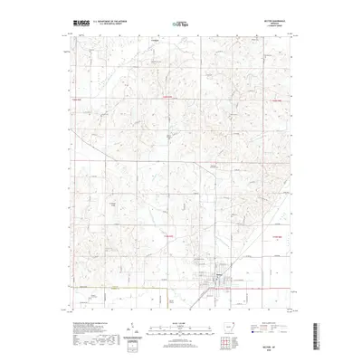
2020 Map of Rector
USGS Topo · Published 2020About this map
Crowleys Ridge rises above the alluvial plains of the Arkansas Delta in this 2020 record of Clay County. The city of Rector sits at the base of this unique geological formation, showing its modern street grid and the nearby Rector Airport. The landscape is defined by the transition from the elevated ridge to the low-lying wetlands and creek systems that flank it. Numerous family and community burial grounds are scattered across the terrain, including Woodland Cem, Pleasant Grove Cem, and Liberty Hill Cem, providing a dense network of sites for genealogical research. The drainage patterns of the region are clearly visible through the winding paths of White Walnut Creek, Post Oak Creek, and Big Creek. This map illustrates the contemporary road system where county routes like Co RD 440 and Co RD 418 connect the small community of Crockett with the surrounding agricultural lands and neighboring Greene County.
Find a feature on this map
97 named features on this map. Tap any name to fly to it.
Don’t see what you’re looking for? This feature index may not catch every label — zoom into the map to look around manually.
Map Details
Editions of this 2020 Rector Map
This is the sole edition of this map. No revisions or reprints were ever made.
Other maps of this area

1934 · Kennett
USGS Topo · 1:62,500

1935 · Rector
USGS Topo · 1:62,500

1940 · Marmaduke
USGS Topo · 1:62,500

1940 · Kennett
USGS Topo · 1:62,500

1940 · Piggott
USGS Topo · 1:62,500

1956 · Kennett
USGS Topo · 1:62,500

1956 · Piggott
USGS Topo · 1:62,500

1957 · Poplar Bluff
USGS Topo · 1:250,000

1958 · Marmaduke
USGS Topo · 1:62,500

1958 · Rector
USGS Topo · 1:62,500