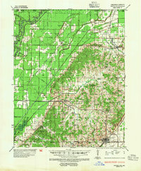
1935 Map of Rector
USGS Topo · Published 1954About this map
Rector serves as the primary hub in this mid-1930s survey, where the St Louis San Francisco RR cuts through the lowlands of Clay and Greene Counties. The topography is dominated by the rise of Crowleys Ridge, a distinct geological formation that elevates the landscape above the surrounding wetlands and drainage projects like Ditch No 19 and Ditch No 25. This elevated ground is heavily dotted with family-centric landmarks and rural social centers, including Boydeville, Crockett, and Hikoria.
Find a feature on this map
111 named features on this map. Tap any name to fly to it.
Don’t see what you’re looking for? This feature index may not catch every label — zoom into the map to look around manually.
Map Details
Editions of this 1935 Rector Map
3 editions found
Other maps of this area

1934 · Kennett
USGS Topo · 1:62,500

1935 · Acorn
USGS Topo · 1:62,500

1935 · Rector
USGS Topo · 1:62,500

1935 · Knobel
USGS Topo · 1:62,500

1935 · Harviell
USGS Topo · 1:62,500

1940 · Naylor
USGS Topo · 1:62,500

1940 · Gainesville
USGS Topo · 1:62,500

1940 · Marmaduke
USGS Topo · 1:62,500

1940 · Valley Ridge
USGS Topo · 1:62,500

1940 · Kennett
USGS Topo · 1:62,500