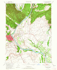
1951 Map of Red Bluff East
USGS Topo · Published 1965About this map
Red Bluff serves as the focal point of this 1951 topographic survey, situated at a strategic bend of the Sacramento River where the Southern Pacific railroad parallels the western bank. The landscape is a complex network of seasonal drainages and irrigation infrastructure, including the Irrigation Canal and a Diversion Dam that support the surrounding agricultural tracts. The map details the civic development of the era, from the centrally located County Fair Grounds to a series of educational institutions like Union High Sch and Bidwell Jr High Sch.
Find a feature on this map
44 named features on this map. Tap any name to fly to it.
Don’t see what you’re looking for? This feature index may not catch every label — zoom into the map to look around manually.
Map Details
Editions of this 1951 Red Bluff East Map
5 editions found
Other maps of this area

1890 · Red Bluff
USGS Topo · 1:250,000

1894 · Red Bluff
USGS Topo · 1:250,000

1905 · Tehama
USGS Topo · 1:62,500

1944 · Tuscan Buttes
USGS Topo · 1:62,500

1947 · Tuscan Buttes
USGS Topo · 1:62,500

1947 · Anderson
USGS Topo · 1:62,500

1948 · Anderson
USGS Topo · 1:62,500

1950 · Gerber
USGS Topo · 1:24,000

1951 · Gerber
USGS Topo · 1:24,000

1951 · Red Bluff East
USGS Topo · 1:24,000