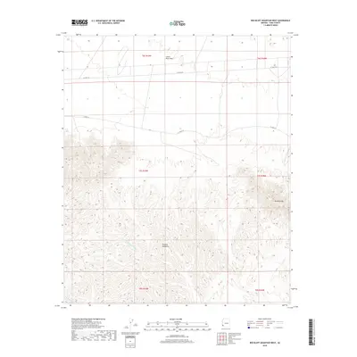
2018 Map of Red Bluff Mountain West
USGS Topo · Published 2018About this map
Red Bluff Mtn stands as a prominent landmark within this arid landscape of Yuma County, marking a transition from the elevated peaks of the Muggins Mountains to the expansive Castle Dome Plain. The map reveals a network of ephemeral drainage patterns, most notably Vinegarroon Wash and Morgan Wash, which define the local topography. Human activity in this desert environment is delineated by a sparse grid of roads, including Co 3rd ST N and Co 2nd ST N, which cut across the vast plains and foothills. The terrain is characterized by intricate contouring that illustrates the complex geological formations of the southwestern Arizona desert, where dry washes serve as the primary natural corridors through the high-relief mountain ranges.
Find a feature on this map
13 named features on this map. Tap any name to fly to it.
Don’t see what you’re looking for? This feature index may not catch every label — zoom into the map to look around manually.
Map Details
Editions of this 2018 Red Bluff Mountain West Map
This is the sole edition of this map. No revisions or reprints were ever made.
Other maps of this area

1926 · Fortuna
USGS Topo · 1:62,500

1926 · Wellton
USGS Topo · 1:62,500

1929 · Fortuna
USGS Topo · 1:62,500

1929 · Laguna
USGS Topo · 1:62,500

1929 · Wellton
USGS Topo · 1:62,500

1942 · Yuma
USGS Topo · 1:250,000

1943 · Laguna
USGS Topo · 1:62,500

1954 · El Centro
USGS Topo · 1:250,000

1955 · El Centro
USGS Topo · 1:250,000
1955 · Dome
USGS Topo · 1:24,000