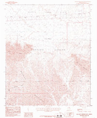
1986 Map of Red Bluff Mountain West
USGS Topo · Published 1986About this map
The Yuma Proving Ground dominates this arid landscape in Yuma County, characterized by the stark intersection of military testing infrastructure and raw desert terrain. The northeastern portion of the quadrangle is defined by the expansive Castle Dome Plain, while the southern reaches are crowded by the complex ridges of the Muggins Mountains and Red Bluff Mountain. This area serves as a significant site for high-altitude observation and defense testing, noted by several Observation Tower locations and numerous scattered Prospect labels that hint at historical mineral exploration in the canyons.
Find a feature on this map
21 named features on this map. Tap any name to fly to it.
Don’t see what you’re looking for? This feature index may not catch every label — zoom into the map to look around manually.
Map Details
Editions of this 1986 Red Bluff Mountain West Map
This is the sole edition of this map. No revisions or reprints were ever made.
Other maps of this area

1926 · Fortuna
USGS Topo · 1:62,500

1926 · Wellton
USGS Topo · 1:62,500

1929 · Fortuna
USGS Topo · 1:62,500

1929 · Laguna
USGS Topo · 1:62,500

1929 · Wellton
USGS Topo · 1:62,500

1942 · Yuma
USGS Topo · 1:250,000

1943 · Laguna
USGS Topo · 1:62,500

1954 · El Centro
USGS Topo · 1:250,000

1955 · El Centro
USGS Topo · 1:250,000
1955 · Dome
USGS Topo · 1:24,000