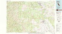
1979 Map of Red Bluff
USGS Topo · Published 1979About this map
The Sacramento River carves a central path through this Northern California landscape, anchoring a network of agricultural communities and river-oriented infrastructure. This survey captures the transition from the fertile valley floor to the high elevations of the Trinity Mountains and the Yolla Bolly Middle Eel Wilderness to the west. The development of Red Bluff is shown in detail, including the Red Bluff Municipal Airport and the Red Bluff Diversion Dam, which managed the river's flow for the region's expansive ranching and farming operations.
Find a feature on this map
57 named features on this map. Tap any name to fly to it.
Don’t see what you’re looking for? This feature index may not catch every label — zoom into the map to look around manually.
Map Details
Editions of this 1979 Red Bluff Map
3 editions found
Other maps of this area

1886 · Lassen Peak
USGS Topo · 1:250,000

1890 · Red Bluff
USGS Topo · 1:250,000

1891 · Chico
USGS Topo · 1:125,000

1892 · Lassen Peak
USGS Topo · 1:250,000

1893 · Chico
USGS Topo · 1:125,000

1894 · Lassen Peak
USGS Topo · 1:250,000

1894 · Red Bluff
USGS Topo · 1:250,000

1895 · Chico
USGS Topo · 1:125,000

1901 · Redding
USGS Topo · 1:125,000

1904 · Vina
USGS Topo · 1:62,500