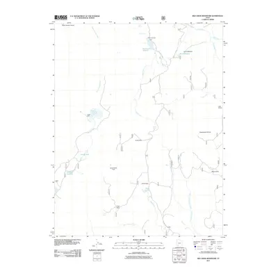
2011 Map of Red Creek Reservoir
USGS Topo · Published 2011About this map
Red Creek Reservoir dominates the high-altitude hydrology of this Iron County landscape, controlled by the Red Creek Dam along the upper reaches of Red Creek. The topography is defined by a series of high valleys and canyons that organize the movement of water and travelers, including Forks Valley, Kings Valley, and Myers Valley. A network of smaller water management sites, such as Robinson Reservoir and Foster Dam, indicates a history of livestock grazing and local water conservation in this terrain.
Find a feature on this map
32 named features on this map. Tap any name to fly to it.
Don’t see what you’re looking for? This feature index may not catch every label — zoom into the map to look around manually.
Map Details
Editions of this 2011 Red Creek Reservoir Map
This is the sole edition of this map. No revisions or reprints were ever made.
Other maps of this area

1886 · Kanab
USGS Topo · 1:250,000

1953 · Cedar City
USGS Topo · 1:250,000

1958 · Cedar City
USGS Topo · 1:250,000

1958 · Cedar Breaks
USGS Topo · 1:62,500

1958 · Panguitch Lake
USGS Topo · 1:62,500

1962 · Cedar City
USGS Topo · 1:250,000

1971 · Paragonah
USGS Topo · 1:24,000
1971 · Cottonwood Mtn
USGS Topo · 1:24,000

1971 · Fivemile Ridge
USGS Topo · 1:24,000

1971 · Parowan
USGS Topo · 1:24,000