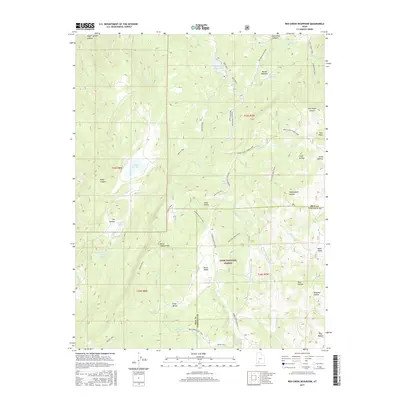
2017 Map of Red Creek Reservoir
USGS Topo · Published 2017About this map
The Markagunt Plateau dominates this high-elevation landscape, where the headwaters of the Red Creek drainage are managed through a series of mountain impoundments. The centerpiece, Red Creek Reservoir, is joined by smaller upland water bodies including Foster Reservoir, Robinson Reservoir, and the natural Horse Lake. Located within the Dixie National Forest along the border of Iron and Garfield counties, the area is defined by its network of backcountry routes. Notable paths such as the Spruce Trail and Grand Dad Flat Trail connect high points like Horse Valley Peak with numerous namesake hollows and valleys. The presence of the Mud Springs ATV Trail and the Spoon Trail illustrates the transition of this territory from traditional livestock grazing towards modern recreational use in the early twenty-first century.
Find a feature on this map
53 named features on this map. Tap any name to fly to it.
Don’t see what you’re looking for? This feature index may not catch every label — zoom into the map to look around manually.
Map Details
Editions of this 2017 Red Creek Reservoir Map
This is the sole edition of this map. No revisions or reprints were ever made.
Other maps of this area

1886 · Kanab
USGS Topo · 1:250,000

1953 · Cedar City
USGS Topo · 1:250,000

1958 · Cedar City
USGS Topo · 1:250,000

1958 · Cedar Breaks
USGS Topo · 1:62,500

1958 · Panguitch Lake
USGS Topo · 1:62,500

1962 · Cedar City
USGS Topo · 1:250,000

1971 · Paragonah
USGS Topo · 1:24,000
1971 · Cottonwood Mtn
USGS Topo · 1:24,000

1971 · Fivemile Ridge
USGS Topo · 1:24,000

1971 · Parowan
USGS Topo · 1:24,000