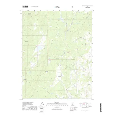
2020 Map of Red Creek Reservoir
USGS Topo · Published 2020About this map
The Markagunt Plateau high country defines this 2020 map, where the border of Iron and Garfield counties crosses a landscape of high-altitude valleys and watersheds. Water management is central to the area's geography, anchored by the Red Creek Reservoir in the north and the smaller Robinson Reservoir and Hoosier Lake to the west. These bodies of water, along with named sources like Mud Springs and Cove Spring, support a region dedicated largely to the protected acreage of the Dixie National Forest. A network of backcountry routes, including the Sandy Caddy Creek Loop and Grand Dad Flat Trail, provides access to distinctive landforms such as Twin Peaks and the sweeping Horse Valley. The map also preserves local nomenclature for the numerous hollows and canyons, such as Shakespeare Hollow and Mortensen Canyon, reflecting the area's history of ranching and exploration.
Find a feature on this map
49 named features on this map. Tap any name to fly to it.
Don’t see what you’re looking for? This feature index may not catch every label — zoom into the map to look around manually.
Map Details
Editions of this 2020 Red Creek Reservoir Map
This is the sole edition of this map. No revisions or reprints were ever made.
Other maps of this area

1886 · Kanab
USGS Topo · 1:250,000

1953 · Cedar City
USGS Topo · 1:250,000

1958 · Cedar City
USGS Topo · 1:250,000

1958 · Cedar Breaks
USGS Topo · 1:62,500

1958 · Panguitch Lake
USGS Topo · 1:62,500

1962 · Cedar City
USGS Topo · 1:250,000

1971 · Paragonah
USGS Topo · 1:24,000
1971 · Cottonwood Mtn
USGS Topo · 1:24,000

1971 · Fivemile Ridge
USGS Topo · 1:24,000

1971 · Parowan
USGS Topo · 1:24,000