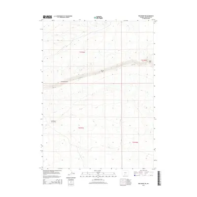
2015 Map of Red Desert SW
USGS Topo · Published 2015About this map
The Continental Divide defines the high-desert character of this corner of Sweetwater County, where the landscape transitions through significant geological formations. Along the northern edge of the survey, the Delaney Rim and Wells Bluff create a prominent east-west escarpment that dictates the flow of drainage and the placement of early transport corridors. To the south, the terrain descends into more open country, marked by the ephemeral waters of North Barrel Springs Draw. This 2015 data reflects a sparsely settled portion of the high plains, where human impact is largely limited to the network of local routes like CO Road 3313 and Cr-3323 which follow the natural contours of the rim and the divide.
Find a feature on this map
10 named features on this map. Tap any name to fly to it.
Don’t see what you’re looking for? This feature index may not catch every label — zoom into the map to look around manually.
Map Details
Editions of this 2015 Red Desert SW Map
This is the sole edition of this map. No revisions or reprints were ever made.
Other maps of this area

1954 · Rock Springs
USGS Topo · 1:250,000

1958 · Rock Springs
USGS Topo · 1:250,000

1962 · Rock Springs
USGS Topo · 1:250,000

1970 · Red Desert SW
USGS Topo · 1:24,000
1970 · Red Desert SE
USGS Topo · 1:24,000

1970 · Red Desert NW
USGS Topo · 1:24,000

1970 · J O Dugway
USGS Topo · 1:24,000

1970 · Fort La Clede NE
USGS Topo · 1:24,000

1970 · Tipton
USGS Topo · 1:24,000
1970 · Haystack Flats
USGS Topo · 1:24,000