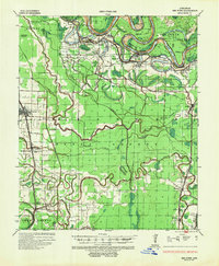
1935 Map of Red Fork
USGS Topo · Published 1953About this map
The Arkansas River dominates this 1935 landscape, winding through a complex series of tight oxbows and bends including Pendleton Bend, Memphis Bend, and Red Fork Bend. This survey, conducted under the Mississippi River Commission, illustrates a critical era of flood control along the river's lower reaches. The eastern portion of the sheet is defined by the Missouri Pacific railroad corridor, which links the settlements of Watson, Kelso, and Rohwer. To the west, the line through Dumas, Walnut Lake, and Winchester mirrors this transport pattern, showing how rail lines followed the slightly higher ground between swampy bayous. The intricate drainage network of Oakwood Bayou, Amos Bayou, and Willow Slough reveals the naturally waterlogged state of the Delta before modern drainage projects fully transformed the agricultural landscape. Genealogists will find interest in the Pendleton Ferry crossing and scattered small stops like Medford and Yukon Spur.
Find a feature on this map
54 named features on this map. Tap any name to fly to it.
Don’t see what you’re looking for? This feature index may not catch every label — zoom into the map to look around manually.
Map Details
Editions of this 1935 Red Fork Map
3 editions found
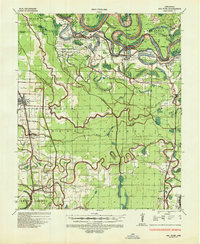
Other maps of this area

1933 · Lamont
USGS Topo · 1:62,500

1935 · Cominto
USGS Topo · 1:62,500

1935 · Varner
USGS Topo · 1:62,500

1935 · Rotan
USGS Topo · 1:62,500

1935 · Red Fork
USGS Topo · 1:62,500

1935 · Gillett
USGS Topo · 1:62,500

1936 · McGehee
USGS Topo · 1:62,500

1937 · McGehee
USGS Topo · 1:62,500

1939 · Henrico
USGS Topo · 1:62,500

1939 · Big Island
USGS Topo · 1:62,500