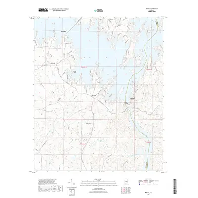
2018 Map of Red Hill
USGS Topo · Published 2018About this map
Martin Lake dominates the upper half of this landscape, its intricate fingers and inlets creating a complex shoreline at the Elmore and Tallapoosa county line. The settlement of Kowaliga sits near the water's edge, characterized by points such as Bear Bryant Pt and Rocky Point. Further south, the community of Red Hill serves as a central hub for a network of country roads, including Hollis Ferry Rd and Double Bridge Ferry Rd, which hint at historical river crossings long since superseded by modern infrastructure. The terrain transitions from the developed lakefront to the winding drainage of Channahatchee Creek and the Tallapoosa River. Genealogists will find several burial sites preserved on this sheet, including Prospect Cem, Lovejoy Cem, and Watson Chapel Cem, while industrial history is signaled by the presence of Gold Mine Rd near the southern boundary.
Find a feature on this map
97 named features on this map. Tap any name to fly to it.
Don’t see what you’re looking for? This feature index may not catch every label — zoom into the map to look around manually.
Map Details
Editions of this 2018 Red Hill Map
This is the sole edition of this map. No revisions or reprints were ever made.
Other maps of this area

1901 · Wetumpka
USGS Topo · 1:125,000

1901 · Wetumpka
USGS Topo · 1:62,500

1903 · Wetumpka
USGS Topo · 1:125,000

1906 · Dadeville
USGS Topo · 1:125,000

1953 · Montgomery
USGS Topo · 1:250,000

1955 · Phenix City
USGS Topo · 1:250,000

1956 · Montgomery
USGS Topo · 1:250,000

1957 · Phenix City
USGS Topo · 1:250,000

1957 · Montgomery
USGS Topo · 1:250,000

1958 · Phenix City
USGS Topo · 1:250,000