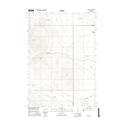
2017 Map of Red Hills
USGS Topo · Published 2017About this map
The Little Lost River Valley forms a significant low-lying corridor through the high-altitude terrain of Custer and Butte Counties in this 2017 survey. The landscape is defined by the prominent Red Hills and the Donkey Hills to the northwest, with Taylor Mtn rising between various drainage systems. Water sources are critical in this environment, represented by reliable points like Mud Spring and Camp Springs. The map documents a complex network of seasonal and perennial flows, including Dry Creek, Corral Cr, and Wet Cr, which illustrate the hydraulic patterns of the region. Transportation is sparse, primarily limited to routes like Pass Creek Rd and Nat For Dev Rd 119, reflecting the transition from the valley floor to the more isolated upland reaches of the Sawtooth National Forest area.
Find a feature on this map
23 named features on this map. Tap any name to fly to it.
Don’t see what you’re looking for? This feature index may not catch every label — zoom into the map to look around manually.
Map Details
Editions of this 2017 Red Hills Map
This is the sole edition of this map. No revisions or reprints were ever made.
Other maps of this area

1935 · Borah Peak
USGS Topo · 1:125,000

1938 · Borah Peak
USGS Topo · 1:125,000

1955 · Dubois
USGS Topo · 1:250,000

1956 · Donkey Hills
USGS Topo · 1:62,500

1957 · Gilmore
USGS Topo · 1:62,500

1957 · Hawley Mountain
USGS Topo · 1:62,500

1958 · Dubois
USGS Topo · 1:250,000
1967 · Massacre Mtn
USGS Topo · 1:24,000
1967 · Short Creek
USGS Topo · 1:24,000
1987 · Mulkey Bar
USGS Topo · 1:24,000