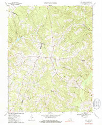
1968 Map of Red House
USGS Topo · Published 1986About this map
Red House serves as a central junction where three Virginia counties meet, following a landscape shaped by the Falling River and its numerous tributaries. This late 1960s survey documents a rural Southside Virginia region where local identity is anchored by small crossroads and country churches. A cluster of spiritual landmarks, including Trinity Ch, Mt Zion Ch, and Beautiful Zion Ch, surround the main settlement, reflecting a dense social fabric within a sparse population. To the east, Rolling Hill marks another upland community, while the presence of Madison Mill along Madison Mill creek suggests the area’s historic reliance on water-powered industry. The terrain is deeply etched by a network of drainages like Marrowbone Creek and Steele Creek, indicating a land shaped by agriculture and timber, further underscored by modern infrastructure like the prominent Pipeline corridor crossing the county lines.
Find a feature on this map
34 named features on this map. Tap any name to fly to it.
Don’t see what you’re looking for? This feature index may not catch every label — zoom into the map to look around manually.
Map Details
Editions of this 1968 Red House Map
2 editions found
Other maps of this area

1892 · Appomattox
USGS Topo · 1:125,000

1947 · Roanoke
USGS Topo · 1:250,000

1956 · Brookneal
USGS Topo · 1:62,500

1956 · Charlotte Court House
USGS Topo · 1:62,500

1958 · Appomattox
USGS Topo · 1:62,500

1958 · Pamplin City
USGS Topo · 1:62,500

1959 · Roanoke
USGS Topo · 1:250,000

1963 · Roanoke
USGS Topo · 1:250,000
1966 · Mike
USGS Topo · 1:24,000
1966 · Brookneal
USGS Topo · 1:24,000